High
Altitude Balloon Carrying Amateur Television - 3
HABCAT-3 on LARG Flight 2004A August 7, 2004
Conducted By The Balloon Committee of the Loudoun Amateur Radio Group of Northern Virginia
Search
- Yes !! and Recovery - Not !!
Reported by Norm Styer - AI2C - - Photograph credit at curser
over photos.
In
general, the success of the search and recovery operation depends
on knowing where you should go and an ability to listen for and locate
the beacon signal. Sometimes, we get lucky and we have good GPS coordinates
and we just drive up to the touchdown. But most often, as with the
LARG Flight 2004A, we needed to rely on our bearing data, the rate
of decent, the nature of the signal at 'Loss of Signal,' and the
lay of the terrain in the projected touchdown area. Sometimes going
to high ground will reveal the beacon signal; sometime driving all
roads in a grid fashion will work, and sometimes, just 'dumb luck'
will 'smoke out' the beacon. Once detected, we report telemetry data
on condition of the battery which tells us how much time we have
before it shuts down, and we keep a 'radio watch' on it until others
can be contacted, moved into the area and acquire the signal. Then
it is just a matter of walking in on the beacon with portable direction
finding gear and trusty attenuators.
Well, that
was the general plan for LARG Flight 2004A. We all expected that
it would only be a matter of time before someone reported acquisition.
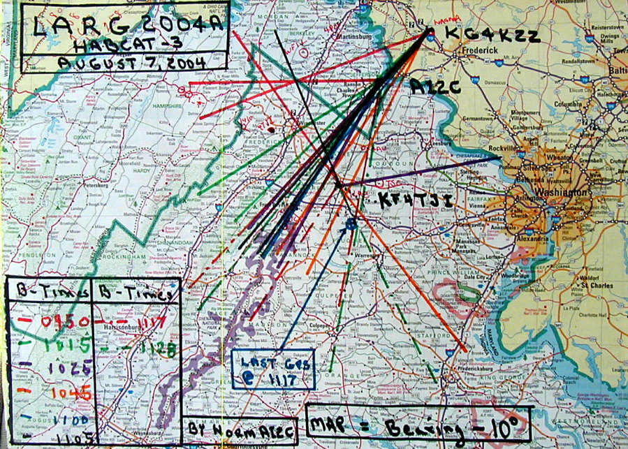
The information we had is shown on the map above and it was clear the the flight
spent considerable time near or overhead Denny and Carol's Tracking
Site near Sky Meadows as their bearing reports indicate.They couldn't
resolve a 1105 hour bearing and concluded it was overhead. See the
raw data collection sheet at the bottom of this page. The last two
bearing readings at 1117 and 1128 hours were key. And Denny had reported
that the S-4/5 signal strength abruptly disappeared at LOS; this most
likely indicates that it dropped over a ridge close to their location
at touchdown. So, south and east of Marshall was a good place to start.
By 1230
hours even the northern tracking teams of Dave Putman - KG4KZZ assisted
by Kurt Reber - KI4FWB who were northwest of Frederick, MD., and Norm
Styer - AI2C who was west of Harper's Ferry were in the search area
and taking directions from Tom Dawson - WB3AKD on which roads to travel.
Carol and Denny Boehler - KF4TJJ and KF4TJI and Tom Dawson - WB3AKD
who were both tracking from near Sky Meadows were already riding good
routes. With 4 mobile units saturating the area, surely acquisition
would be soon. Mark Johnson - W3ZI had been in the area earlier and
about 1300 hours joined in the search. Then about 1400 hours, Ian Fadyen
- W4/G4JMM drove out from the Washington DC area to help. So now, about
1430 hours, we had six mobile units on the search.
Around
1400 hours, Tom Dawson - WB3AKD stood down and cranked up his generator
and reviewed the recorded video and determined that the last good GPS
display occurred at 1117 hours at about 10 minutes before LOS. These
coordinates were south and west of Marshall and just south of I-66.
Knowing that surface winds were almost directly out of the west, the
south and east of Marshall still looked good.
![]()
The 1600 Hour Conference - So Where Haven't We Looked?
L-R: Norm Styer - AI2C, Tom Dawson - WB3AKD and Denny Boehler - KF4TJJ
After another round of passes on the most likely routes, we decided to meet at 1600 hours near Route 55 and I-66 to confer in person on 'what's up.' Ian Fadyen, Dave Putman and Kurt Reber met further east near Marshall for an 'Eye-Ball QSO.' Mark Johnson, Tom, Denny, Carol and Norm picked some more likely areas. Norm went further east toward Route 15 and Haymarket and searched areas between I-66 and Route 29 south toward Warrenton. Tom decided to go up on the Blue Ridge and listen for a weak signal.
![]()
Carol Boehler - KF4TJJ - A Trusty Side-Kick !!!
Search
teams continued in the area until around 1800 hours; each concluded
they had done their best. Tom Dawson heard nothing from the Blue
Ridge and others began to fade and closed for home. By 1930 hours
all had closed.
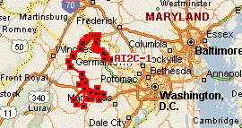
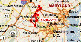
Navigating
with GPS, APRS and computers proved very useful. AI2C and KG4KZZ were
beaconing on 144.390 MHz so their locations were available on the
Internet and to each other via their connected radio-GPS unit. The
two maps below show what was captured and reported by local Internet
connected APRS stations. Norm Styer also used his laptop's Garmin
Map Source program to verify locations and look at more road details.
A real time mobile IGATE link is something to look at for the next
operation.
Norm Styer - AI2C put 300 plus miles on his Ford F-150
Dave Putman - KG4KZZ reported 200 plus miles
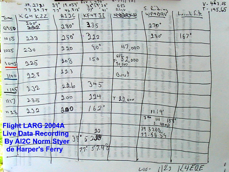
It's Still Stubby Pencil Time When Raw Data Rolls In !!
Later
Sunday night, Tom Dawson - WB3AKD reported on the LARG Sunday Night
2-Meter Net that analysis of the launch video showed that there was
an apparent intermittent in the telemetry package. In the rush of launching
with the second balloon it appeared that the Telemetry Package was
not working until it was accidentally dropped during launch and it
reactivated. Tom believes that something happen on the initial try,
overlooked during the second launch and was accidentally and most likely
temporally fixed when dropped. He further concluded the the intermittent
reoccurred upon touchdown. Thus shutting down the beacon. Thus we most
likely searched in vain.
Tom Dawson
also believes that a disturbance like windy conditions may reactivate
the beacon package and we should be prepared to revisit the search
area if weather conditions change. There should be at least 4 hours
of power available for the beacon. Or, more likely, a farmer, horseback
rider or hunter will discover the units and return them for the reward
posted on each unit.
It was nice riding with you
all. I know those that rode enjoyed it and I hope we all learned something.
Best Regards, Norm Styer - AI2C.