K4LRG / Balloon
Flight 2008A

Conducted By The Balloon Committee
of the
Loudoun Amateur Radio Group
of Northern Virginia


MP3 Clip of Operations
Recorded, Produced & Provided By
NE3Z - Dan Goodson of Arlington, VA. Thanks, Dan. Cool Work!

With reports, audio track, video, and photographs By WB3AKD - Tom Dawson, Suzanne Grobbel, KI4IEO - Chuck Graham, K8SYH - Bill Buchholz, AI4ID - Sean Sheedy, WA4LDA - Stevens Miller, NE3Z - Dan Goodson, Denny Boehler - KF4TJI,   AI1V - Rick Miller, and AI2C - Norm Styer. Place cursor on a photograph to see credits. Free DHTML scripts provided by Dynamic Drive    Edited and published on K4LRG.ORG by AI2C - Norm Styer.


Flight 2008A Launch at 0900 hours July 19, 2008. Photograph by Stevens Miller - WA4LDA of Ashburn, Virginia.

The landing zone. K4LRG/B is Down and Found. Photograph by Norm Styer - AI2C de Clarkes Gap, Virginia.

Down & Found

      (Purcellville, VA. July 20, 2008)  The Balloon Committee of the Loudoun Amateur Radio Group conducted a very successful launch, tracking and recovery operation of its K4LRG/B Flight 2008A Balloon Flight on Saturday, July 19, 2008, in northern Virginia. Preparations began in earnest in early July. Tom Dawson - WB3AKD designed and built the flight package and launch hardware. Sean Sheedy - AI4ID took over mission control duties and with a lot of help from all our members, they pulled off a nice flight tracking and recovery operation. Our preparations are recorded here. Throughout the week before launch, Tom Dawson monitored winds aloft and ran Balloon Track each day to determine the best launch site. Our target was west on the Blue Ridge in Clarke County and if necessary, Loudoun County east of the Blue Ridge. The Launch Team settled on a public park near Summit Point, in Jefferson County, WV.

        We deployed five tracking teams at sites which would look into the predicted flight path area. Norm Styer - AI2C was at Harpers Ferry, WV., Jay Greeley - KI4UTB was at Snickers Gap on the Clarke - Loudoun County line, Chuck Graham - KE4IEO was in the south near Routes 17 and I-66. Denny Boehler - KF4TJI was on North Mountain west of Winchester and the launch team at Summit Point with Dave Putman - KE4S also provided tracking data. We also had Charlie Preston - K4LJH in Hamilton monitoring and recording the telemetry and assisting with bearings once the payload was down. Gary Quinn - NC4S assisted from his station north of Waterford and was the first to reach the LZ. Rick Miller - AI1V provided reports of significant changes in the flight and 'punched in' all the CW telemetry data - now that's cool. Finally, many others throughout Virginia, Maryland, West Virginia and Pennsylvania monitored and sometimes provided observations. We appreciated them all. Mission control operations on the WA4TSC/R repeater on 147.300 MHz was very smooth, mostly well disciplined and got better as the flight continued. Jay Ives - KI4TXP was the voice of mission control and ran a tight net. The MP3 3 minute plus MP3 audio clip was recorded, produced and provided by Dan Goodson - NE3Z from his home in Arlington, VA. This is cool and we hope you all enjoy Dan's work. You may replay with the control above.

The flight are nominal - almost perfect. Launch was at 9 AM and the tracking teams had no trouble copying the 600 milliwatts old Radio Shack transmitter signal on 145.650 MHz. It was so nice to hear perfect 20-WPM Charlie Whiskey. We flew with a very old 1993 600-gram balloon but it did make it to 70,000 plus feet before fatigue set in - it gets very cold up there and the material get very brittle. By 10:30 AM morning winds have picked up and after burst they carried it well into Loudoun County.

Recovery was a breeze. It's always nice not to completely lose the signal and in this case many continued to monitor the payload at 5-plus miles. It was in good health battery power wise. So, we quickly drove to within a mile or two and then with great luck spotted it in a tree in a backyard just off Taylorstown road in northeastern Loudoun County.

After the proverbial cut-down ceremony, we all adjourned to the Talk of the Town in Lovettsville for lunch. It was a nice flight. And, it was great riding with you all. Best Regards, Norm Styer - AI2C de Clarkes Gap, Virginia.

.

K4LRG/B Flight 2008A
                          By Tom Dawson - WB3AKD, Chairman, Balloon Committee of the Loudoun Amateur Radio Group

        (Round Hill, Virginia – July 20, 2008)   Launch lead, Tom Dawson, WB3AKD, and Suzanne Grobbel, along with the Balloon Launch Apparatus and Payload departed the home QTH about 0640 and headed toward the launch site at Jefferson County park outside of Summit Point WV.

        We met up with, Sean, AI4ID, at Rte 7 and US 340 to drop a CD with the spreadsheet for converting Barometer Counts to Altitude and then headed north on 340.

        As is usual on operations of this type, I missed the turn off 340 but found it on the return south and headed off toward Summit Point. At Summit point, I actually made the correct turn the first time, but it having been over a year since I was in the area, I lost confidence, turned around and went off on another road looking for the park, while John, W4AU and Dave, KE4S went exploring Summit Point. Finally, Suzanne took the situation in hand and dug out the Jefferson County Map she'd given me some time before, and we were able to find the park. We arrived about 0800, and found it to be an outstanding launch/tracking location.

        A few minutes later we were all there, John, W4AU, Dave, KE4S, Stevens, WA4LDA, Jeff, KE5APC, Suzanne, and myself, WB3AKD.

        First thing was to get a time hack from CHU which was accomplished at 0804.

        Next I pulled out the Helium tank and John proceeded to set up all the fill apparatus, and we set out the tarp and pad for the balloon. Meanwhile I set up the telemetry receiver and recording computer.

        We had the flight train set out, and all hooked up and the balloon ready to fill by 0820 or so and were starting to fill the balloon when I realized we were getting ahead of the procedure, so we backed off, and told Mission Control we were through our procedure up to Step 4 and stood by for the trackers to get into position.

        The payload was activated a few times for testing and was activated for flight at 0825.

        About 0840 we asked to poll the trackers and found that at least two were ready and began to fill the balloon. With John steadying the balloon to prevent twisting, filling went smoothly, and by 0850 the balloon was filled with the appropriate amount of helium. John and I tied off the neck and attached the rest of the train. Due to surface winds appearing to pick up, we decided to launch at 0855, so with Suzanne holding the backup parachute to act as a windsock, I took the balloon upwind, and John held the payload and at 0855, with Stevens, Jeff and Dave observing and photographing the launch, the balloon was released and the payload was soon ascending with a little wind rattle of the measuring tape ground radials. The payload was soon out of site and sending regular telemetry frames.

        The flight continued to something in excess of 70000 feet where the balloon burst and telemetry indicated normal rapid decent, decreasing as the air density increased. Signal was lost at about the same time as most everyone else, 1108 and 20 seconds or so.

        At that point we mounted up and headed back to Loudoun County where Mission Control advised that bearing indicated it had landed in the vicinity of Lovettsville.

        Reports from the Lovettsville indicated a healthy payload transmitting. Signal reports from Joe, N4CX, Gary, NC4S, and Charlie, K4LJH indicated a touchdown point somewhere northwest of Waterford. Further analysis by Sean at Mission Control indicated the Taylorstown area and Gary, going mobile, soon found the parachute dangling from a tree, with the payload still transmitting telemetry.

        Gary contacted the property owner and we were allowed to retrieve the flight train, including a substantial remainder of the balloon envelope.

        Pictures were taken and those with the time headed to Lovettsville for lunch.

        Everyone exhibited outstanding performance. Thanks, Best Regards, Tom Dawson - WB3AKD


K4LRG/B Flight 2008A Participants and Roles
Mission Control Launch Operations Tracking Operations Home Stations

Sean Sheedy - AI4ID and daughters

Jay Ives KI4XP

John Unger - W4AU

Suzanne Grobbel

Tom Dawson - WB3AKD


Summit Point, WV.


      Dave Putman - KE4S

      Stevens Miller - WA4LDA

      Jeff Slusher - KE5APC


Snickers Gap, VA.

      Bonnie Greeley - KJ4BRH

      Jay Greeley - KI4UTB


North Mountain, VA.

      Bill Buchholz - K8SYH

      Denny Boehler - KF4TJI


South of Ashby Gap, VA.

      Chuck Graham - KI4IEO

      Kurt Reber - KI4FWB


Harpers Ferry, WV.

      Norm Styer - AI2C

      Erik Werner - KD5CTJ


Rick Miller - AI1V de Reston, VA.

Gary Quinn - NC4S de Lovettsville, VA.

Charlie Preston - K4LJH de Hamilton,VA.

Joe Faber - N4CX de Round Hill, VA.

Rod Hignite - W4RAH de Lovettsville, VA.

Dan Goodson - NE3Z de Arlington, VA.

Bob Rice - KG4RRN de McLean, VA.


Launch Operations at Summit Point, West Virginia

Ready to Launch at Summitt Gap, West Virginia. Photograph by Stevens Miller - WA4LDA of Ashburn, Virginia.


Launch activities at Summitt Point, West Virginia. Photograph by Stevens Miller - WA4LDA of Ashburn, Virginia.


Launch Operations at Summit Point, West Virginia

    
With the readied payload in the foreground, John Unger - W4AU watches and cares for the balloon as it is inflated.
Launch Operations at Summit Point, West Virginia

Tom Dawson - WB3AKD ties off the neck of the
fully inflated 600-gram balloon.
Tying off the the balloon and payload at Summitt Point, West Virginia. Photograph by Stevens Miller - WA4LDA of Ashburn, Virginia


Launch site telemetry collection station by Tom Dawson - WB3AKD of Round Hill, Virginia. Photograph by Stevens Miller - WA4LDA of Ashburn, Virginia


Launch Operations at Summit Point, West Virginia

The Launch Team used this monitoring station to record telemetry data
and the health of the payload prior to and during flight.


Inflating Flight Balloon  -  A Slide Show

         - By John Unger - W4AU and Tom Dawson - WB3AKD

         - Photographed By Susanne Grobbel and Stevens Miller - WA4LDA

         -
Click On Tabs For Next or Previous Slide

Previous Slide

Next Slide


Launch Operations at Summit Point, West Virginia

K4LRG/B Flight 2008A Launch
by Tom Dawson - WB3AKD and John Unger - W4AU.
Lift Off of Flight 2008A - K4LRG/B at Summitt Point, West Virginia at 0900 hours, Saturday, July 19, 2008. Photograph by Stevens Miller - WA4LDA of Ashburn, Virginia.


Mission Control Operations At Berryville, Virginia

Mission Control set up at Berryville, Virginia. Phtograph by Jay Ives - KI4TXP of Lucketts, Virginia.

It Was A Nice Day For A Picnic !!!


Mission Control
              By AI4ID - Sean Sheedy  and KI5TXP - Jay Ives

Mission Control Summary

       Team lead: Sean AI4ID

       Communications/Net Control: Jay KI4TXP

       Location Plotting: Sean AI4ID

       Altitude Telemetry: Samantha & Cassandra


Reported      Tracking     Bearings
Overlaid on Topo Map - Click Here

Jay Ives - KI4TXP the Voice On Mission Control. Photoghraph by Sean Sheedy - AI4ID.

Jay Ives - KI4TXP
The Voice of Mission Control

        (Leesburg, Virginia – July 22, 2008)  Mission Control (MC) came into existence during the Sunday night net one week before launch and was looking like a one-man team until Wednesday when KI4TXP Jay volunteered. Without Jay, Mission Control likely would have been merely a relay station of bearings and altitudes. Instead, Jay became the key communications element of a team that became increasingly proficient as the flight progressed.

        Mission Control's first activity was securing permission to use the 147.300+ Bluemont repeater. Not only was this quickly provided by Wes Boxwell through Chad Rudolph, the control op, but Chad also volunteered to stick around and place the repeater into and out of net mode. This turned out to be a very welcome resource as the frequency was very busy with balloon operations on flight day, and the presence of a single frequency for operation in Loudoun, Clarke, and other counties was a big relief. This was not fully realized until the station locations were plotted, and it was realized that neither simplex nor the other repeaters probably could have been used without a bunch of relays.

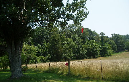
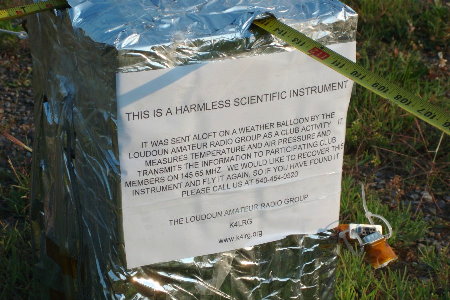
        Permission to use Clarke County Park was then requested and secured. This site was chosen since Berryville was the originally intended landing zone. Getting permission was a good idea since we were questioned by a friendly caretaker while setting up, and having the name of the Parks reservation person was the magic ticket. It turned out to be a fabulous site and we'd recommend it for future balloon events: large shade trees near our vehicles to set up under, not much traffic or noise, relatively good altitude in the valley, able to obtain the balloon signal prior to launch, ability to set up pretty early in the morning, large playground and swimming pool for the family, nearby restrooms, food in town, etc etc.

        Prior to the event, Mission Control then made three announcements about the launch on the NVTN on Tuesday, Thursday, and Friday. This raised local awareness of the event and is responsible for a couple of signal reports that helped Mission Control estimate the balloon's location after landing.

        The only remaining concern was how things would play out on launch day. Neither Jay nor Sean had participated in a ballooning event at this level, so during a long phone call, they walked through the entire procedures document, played out the flight, and wrote down a number of questions for the pros. The email reflector turned out to be a great asset in getting answers to those questions.

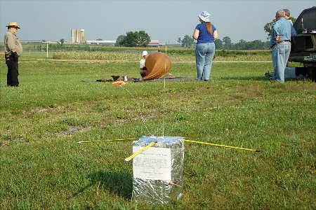
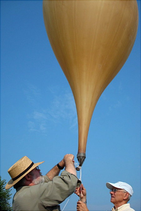
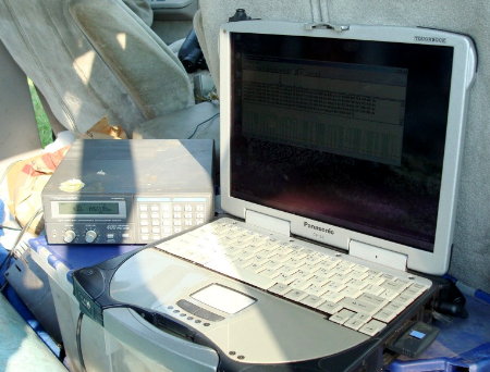
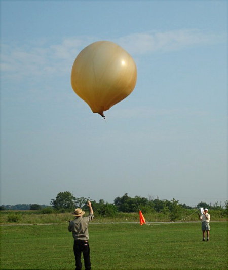
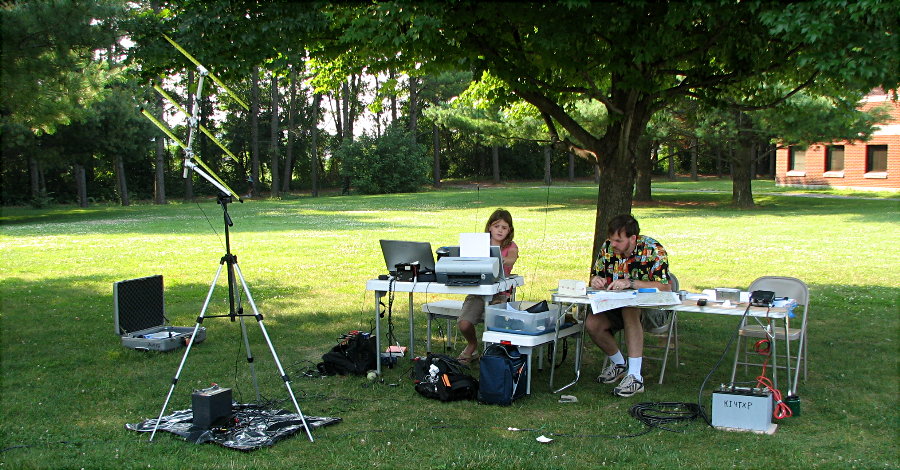
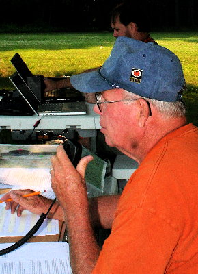
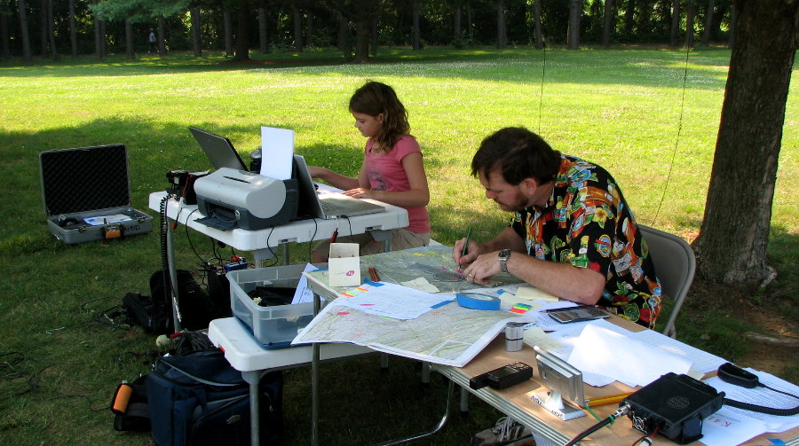
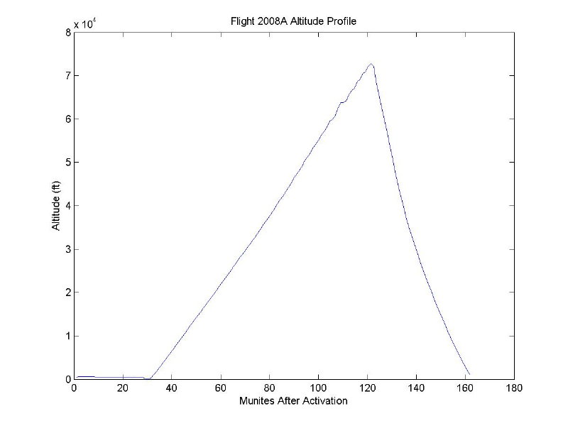
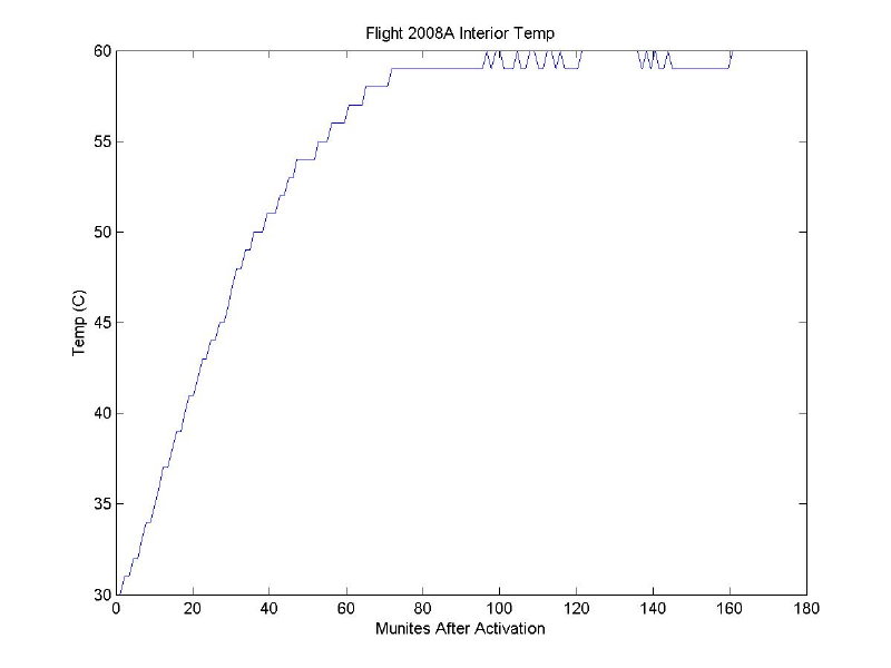
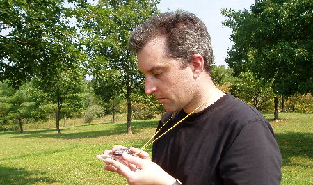
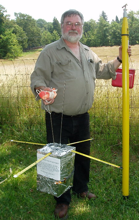
        The day before launch, Sean's daughters decided that they wanted to come along and help. Sean decided to put them to work collecting altitude information, which meant that a telemetry station had to be cobbled together. Using the modifications suggested by Denny KF4TJI during the March LARG meeting, a tape measure beam was rebuilt and mounted onto a camera tripod. An FT-530 (a wonderful early 90s HT produced by Yaesu) was employed as the receiver with a preamplifier. CWGET was used to decode the CW and Tom's baro-to-altitude chart was used to provide altitude information. This gave Mission Control the ability to monitor the package telemetry from before launch to just before landing.

        On launch day, the team fell into the roles of Communications, Plotting, and Altitude Reporting. Jay, a veteran net control, handled this role beautifully, keeping the net together under pressure from both sides of the microphone. Sean handled plotting, reading position reports copied by Jay and providing estimates of balloon position to Jay for transmission. Cassandra copied telemetry from CWGET into a paper log, while Samantha converted baro readings to altitude and reported them to Jay.

        The entire team was new to their roles, and for the first half of the flight there was a lot of scurrying while we learned the ropes. But by the second half, we had time to drink our (now cold) coffee, visit the bathroom, and prepare for LOS.

        People have asked how Mission Control arrived at a pretty good estimate of the balloon location, and we think it reflects the teamwork within Mission Control, the trackers, LARG members, and others who heard our signal and contributed. Everybody did his or her job well and interacted efficiently with everyone else. By looking at the map the plotting station was able to tell which stations were positioned to give the best signal reports for different portions of the balloon flight. The altitude station gave us current and timely information that let us prepare for LOS. The communications station kept information flowing between the net and the other two stations.

        And after LOS, we all simply were fortunate to have the package land where it did, and have some excellent fixes provided by stations that had not yet contributed. Upon LOS, Mission Control estimated the package to be within five miles of Hillsboro, based on LOS times and final tracking station bearings. But it was three Loudoun stations that reported afterwards who provided the bearings that led to the updated position of an area three miles southeast of Lovettsville. One station used the "body attenuation" method that provided even more assurance that the package was in this quadrant.

        Once it was clear that multiple stations were receiving the signal, Mission Control was requested to return to Loudoun to participate in the imminent recovery. But just as we started packing, one of the Loudoun stations provided an updated bearing, that the plotting station penciled in, and with a quick decision, deemed that with so many stations already hearing the signal, an updated location was not required.

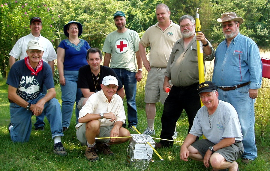
        The package was finally located just inside a three mile radius from the last position we provided over the air. After the lunch celebration, the ride home, and a long-needed nap, the plotting lead opened up the map to examine the final fixes. It turned out that the corrected bearing had placed the balloon in a small area centered on top of Taylorstown!


Observations on the Flight from 'DEBRIEF to AI2C'  of Mission Control Team Chief

        (Leesburg, Virginia – July 20, 2008)   Jay did such a great job handling the net and copying position reports so I just looked over his shoulder. I would copy down a set of readings on a post-it using a different color for each station, then plot it.

        I took flight training in 2002 and 2003 and plotting was one of the training points but I was not proficient. It was rough at first but after the first half dozen readings I started to have faith in the process and it came together in my head.

        The LOS timing thing was great. Based on these I first figured you had an extra long receive because you were peering through a gap into Hillsboro between those two parallel ranges. (Here it really helped knowing the terrain from flying over it during flight training!) KG4RRN's LOS was a big hint that it did not go as far as Lovettsville and the tracks provided by Loudoun stations did not support it.

        I started to hone in on the area 3 miles southeast of Lovettsville from three readings from hams in the area. The ham in Lovettsville who used the "HT against the body" technique and reported ESE confirmed it was south and east of Lovettsville but I wondered why it was not SE. (As we know it indeed was ESE.) Then one of the hams in the area who had given a report that created a triangle in the area I reported, updated his report. At that time we got the call to come in and not miss the fun, and I did not put much more thought into it. I wish I had, though, because looking back at his update (I wish I had erased his old track) his track and the track from two other stations converged (I am pretty sure, I have not completely plotted this) right on top of Taylorstown! I sure wish I had noticed and reported that.

        I was using a tape measure beam at MC that was doing a great job on the telemetry and the girls were in charge of copying altitude readings from CWGET and converting Baro to Altitude which they did like champs, esp. at the end. I had no attenuator and I had just fixed up the beam last night and had never checked it out and it was my first beam so I had no idea how well it worked etc. The back lobe null was not doing much for me. But at LOS I was sure I had the bearing nailed because in the final two telemetry readings I finally got the required attenuation from the signal itself and was getting a sharp drop-off just a few degrees in either direction. I had to switch maps to better plot the Loudoun station position reports and did not copy our own LOS bearing onto that map. After getting home I was dying to see how close it was, I was so certain I had nailed it. Turns out that I had not in fact nailed it but that it was pointing directly at Snickers Gap! Clearly, the low spot and cleared trees provided for a great reflection from the balloon. I actually had noticed a peak in the direction in the last half hour of the flight and was wondering why because your report and others put the balloon further north. Does this correlate to your DF'ing experience? Best Regards, Sean - AI4ID


Looking Back: Mission Control Preparations By AI4ID - Sean Sheedy

        (Leesburg, Virginia – July 17, 2008)   Subject: [QST de K4LRG] Mission Control Status - a few questions too

        Jay - KI4TXP and I spoke on the phone today and we're wrapping up plans for Mission Control. I'll start with questions for the other functions; following that is mission control status.

QUESTIONS FOR TRACKING:

        - Can we please get latitude and longitude for each of the fixed tracking sites and the callsigns they will be using today or early tomorrow? Being within a few seconds (degrees/minutes/seconds) is close enough. This can always change, but we'd like to have a little less to do when we set up on Saturday.

        - Mission control was also wondering if it made sense for all tracking stations to measure balloon heading at the same time, at the top of every ten minutes (:00, :10, :20 etc.) We would start polling tracking stations for the heading taken at that moment one to two minutes later. This helps ensure that triangulation takes place with measurements made at the same instant. Any problem with this?

        - Mission control was wondering if we could take 15-20 minutes around 8 AM to measure the relative error that we might expect from each of the tracking stations. It would be scripted and go like this:

                o Mission control would ask one tracking station to transmit on 145.65 for two minutes (should this be longer or shorter?)

                o Other tracking stations would DF this station.

                o Mission control then polls other tracking stations for measured headings and records them.

                o Process is repeated for most tracking stations, Mission Control, and finally someone from the launch team will transmit.

        We're going to pre-calculate the magnetic headings between all stations ahead of time so that if something is grossly wrong with one station's reports, we can try to do something about it before launch. (All stations should be reporting raw magnetic heading as read directly from a compass). Otherwise, the results would be set aside until after touchdown, or if needed to help get a better estimate of touchdown position during recovery. There is no plan for mission control to apply a per-station correction factor during ops nor to require trackers to do this either - it's too much extra work. This would also help people check out systems and upon the final fix, have all sites fixed on the launch site. We can do this earlier if desired.

        In other words, we don't want to fool around with applying correction factors for each of the individual stations. But having this information could be very helpful in obtaining a refined position if required during the fox hunt. Is this a good or bad idea?

GENERAL QUESTIONS:

        - Are there any special requirements for using the club call (logging, for instance?)

        - Primary mission control repeater frequency is 147.300+. Looking for input on secondary frequency. Choices are:

                o 147.060 (Frederick)
                o 147.255+ PL 123 (Martinsburg)
               o 146.820- (Chad, the 147.300+ control op lives in Winchester and says this machine is just outside Winchester and is "hard to beat" Would like to list two alternates; which two would people recommend (or suggest avoiding?) Anyone have contact info for the owners of these repeaters?

FOR TOM:

        - #17 of Mission Control Procedures says that when tracking teams are ready to travel, we terminal mission control ops. But step 6 of Flight Ops Procedure says that Mission Control terminates ops after payload is found. I assume we will remain on the air to aid in taking mobile tracking team positions and headings, and plotting them until the balloon is found?

        - Are the telemetry measurements made at the start of the transmission, or immediately before the first character of that telemetry element is transmitted?

        - I assume the package is transmitting carrier continuously except when transmitting telemetry or sleeping for a few seconds for thermal cool down?

=======
STATUS
=======

MISSION CONTROL LOCATION:

        Clarke County Park, which is across the street from the site of the Berryville Hamfest (business Route 7, east of Berryville.) Park opens at 7-7:30 but we'll be arriving at 7 and will set up then (the park people tell us we can get in before they open all the gates.) We chose a park so people could come visit if they want to!

MISSION CONTROL PRIMARY FREQUENCY:

        147.300+. No PL is normally needed, but please use PL 146.2 in the event that QRM requires the control op to turn on PL. Backup frequencies to be announced (see above.)

FUNCTIONS:

        Jay is going to be the voice of Mission Control; I am going to be writing down telemetry and headings, plotting them, and providing position info to Jay to report. We will use K4LRG for the callsign. My daughters will be around to help as needed.

PROCEDURES:

        The repeater control op will be enabling the "N" courtesy tone and ops will be conducted as an informal net except during critical aspects of operation (polling for readiness, polling for headings and telemetry, for example.) We'll provide a script. After receiving headings and telemetry from official stations we plan to invite others to provide signal reports and interrupt that to provide the most current calculated location (and nearest major intersection if time permits.)

        After touchdown Mission Control plans to remain on the air to provide additional fox-hunting assistance by collecting anything from basic "I can hear it!" reports to "I'm at such and such lat/long and have DF'd a heading of xxx degrees magnetic."

        That's all I can think of for now; we will post again on Friday. Please answer the questions if you have any input and we look forward to having a lot of fun on Saturday. Best Regards , Sean - AI4ID

On July 17, 2008, Norm Styer - AI2C provide Sean some comments regarding his question:

        Hi Sean, Just, another suggestion. In that we haven't built a separate Tracking and Recovery Team Leader then it would be just great if your Mission Control Group would continue on to coordinate Recovery Operations. The last very few minutes of the flight before the balloon is down and everyone have lost signal - unless we are extremely very lucky and have it hung up on a ridge someplace - is VERY IMPORTANT.

        All trackers should be prepared to provide time and bearing at LOS. We need to know which tracking sites lost signal first, second, etc. and the bearing at LOS. And, I mean separating LOS times by seconds is very important. A time hack before launch for all would help. We need this data captured. This helps understand terrain obstructions and possible areas to either search or not search. For example, if it's east of the Blue Ridge then tracking stations in western Clarke will lose it first.

        The bearings reported during the last few minutes hopefully will be 'tight.' I'd loved to see a 5 x 5 mile square area but often it 10 x 10 or more and often oblong or the thing has over shot it all together. We need this tightness to begin ground vehicle searches in projected landing area. Typically, some should go to 'high' ground - ridges - like Route 601, etc., near the projected landing area and search for a signal out to say 5 to 8 miles or to whatever distance you can see the actual ground. Many times this signal is extremely weak; use no squelch, and your best antenna - be patient in your sweeps. Oh, the signal will sound different with the telemetry and this will often catch your ear before you'll hear any low level carrier.

        Others need to be assigned routes - roads by name - on a cross-hatched pattern that fully covers the projected landing site. In general from experience, stopping on high spots on the local roads every 3/4 mile or less and sweeping the area with a good DF antenna will turn up a signal as far away as 3 miles and more if this 600 mw job is up in a tree. Once someone reacquires the payload then that person reports his bearings and position and stays put while other move into that area to also reacquire the signal. At that point you have 4, 5 ,6 maybe more recovery teams within the area and they should be able to talk themselves into the landing. Central control has done there job at this point.

        Actually finding it is trees and bushes is another story and could take some time. You know you are close when you have to start using your handy-dandy attenuator in order to not pin your receiver's S-Meter. So there's the story, I suggest that you guys at mission control should stay hot at least until we have two trackers with good signals on the downed payload. If possible you can run mobile with two shotguns and get yourself into the projected area. The key to all of this is RE-AOS. I hope this all helps. Best Regards, Norm Styer - AI2C


Mission Control personnel hard at work decoding CW telemetry and plotting reported bearings. Photograph by Jay Ives - KI4TXP of Lucketts, Virginia.

Sean Sheedy - AI4ID and daughter are hard at work plotting bearings and decoding altitude in Morse code.


Flight Telemetry


As has been the practice with our other K4LRG/B flights, Tom Dawson - WB3AKD does the design, development, construction and testing of our flight monitoring system. Balloon Payload Electronics provides information at 20-WPM in Morse code. So Cool !!!

Telemetry frame Is As follows:

             DE K4LRG/B/(FRAME #)/BATT(MV)/BARO(COUNTS)/INT TEMP(K)/EXT TEMP(K)/AR.

             So a typical frame early in the flight would look something like:

             DE K4LRG/B/23/12500/535/305/265/AR

             ID is obvious, K4LRG/B

             Frame number is 23 and will represent about the number of minutes that have passed since activation

             Battery Voltage is 12.5

             Barometer reading is 535: These are raw counts, I still need to calibrate the sensor

             Interior Temperature is 305 K (Subtract 273 to get degrees C)

             Exterior Temperature is 265 K (Subtract 273 to get degrees C)

             AR represent the end of the frame.

The following charts were made by Tom Dawson from the recorded telemetry.

       Altitude in 10's of Thousands of Feet.

Flight 2008A altitude chart developed by Tom Dawson - WB3AKD of Round Hill, Virginia.

      Interior Electronic Package Temperature in Degrees, C.

Flight 2008A payload internal tempature chart developed by Tom Dawson - WB3AKD of Round Hill, Virginia.

      Exterior Package Temperature in Degrees, C.

Flight 2008A external tempature chart developed by Tom Dawson - WB3AKD of Round Hill, Virginia.

      Electronic Package Battery Voltage in Volts, DC.

Flight 2008A payload battery voltage chart developed by Tom Dawson - WB3AKD of Round Hill, Virginia.


Tracking Operations Throughout Virginia and West Virginia


       Tracking from Harpers Ferry, West Virginia
           
               by AI2C - Norm Styer and KD5CTJ - Kurt Werner

        (Clarkes Gap, Virginia, Virginia – July 20, 2008)  We rolled off Canby Road at 0630 hours with anticipation of another great flight tracking operation. We talked about Erik's recent DX-Pedition to EA4 and how he might try an amplifier - Life is too short for QRP. We closed on CW Shipley Elementary School west of Harpers Ferry by 0715 hours to find the Home Land Security emphasis had funded an eight-foot hurricane fence around the whole place. So, what now.

A call out onto our 2-Meter net brought a suggestion from John Unger - W4AU to go back east to the Harper Ferry National Park. So, though the place didn't open till 0800 hours, the gates were open and we picked the highest and most remote spot in the large parking lot to set up. By 0800 hours we were operational and we called in the LAT/LONG of our new location. We played around with a laptop computer running UIView and the DeLorme 3-D TopoQuads programs. The latter, allows you to draw in bearings and thus we thought we might use it to capture all tracking information and help us understand what was happening. We decided not to attempt it this time and instead rely on our manual recording and charting system. This worked but the numbers came in fast and many were not caught as we really concentrated on continuously tracking and preparing for the 10-minute reports.

Our numbers seemed consistent and not until the descending package reach about 35,000 feet did it really start to take off to the east. It was nice to ride it in.

After LOS at 1108 hours, and after hearing NC4S's report that he still had a nice signal, we decided to check the outer limit of travel by going back to east on Route 340 and take Route 15 south into Loudoun. But as further refinements in the location came in, we cut off at Brunswick, Maryland and came down through Loudoun on Route 287. We knew we had a nice recovery possibility when the package began breaking squelch as we pulled off Route 340 at the McDonalds. By the time we reach Lovettsville, the signal was trackable. We elected Milltown Road out of Lovettsville and stopped at Forest Bed Road to confirm directions- about 80 degrees. Another bearing was taken about a 2 miles down Forest Bed Road. We were close - signals at S-8/9. About that time, Gary Quinn called in the recovery site and we all drove to help with cut down.

This was fun. This was too easy. This was welcomed. This was great to be out with all our friends. We hope all enjoyed it as much as we did. Best Regards, Norm Styer - AI2C.


Erik Werner - KD5CTJ manning the tracking antenna at Harpers Ferry, West Virginia. Photograph by Norm Styer - AI2C de Clarkes Gap, Virginia.

Erik Werner - KD5CTJ adjusts the tracking antenna prior to taking another bearing.


The on site traking report recording board and bearing charting by Norm Styer - AI2C at Harpers Ferry, West Virginia. Photograph by Norm Styer - AI2C de Clarkes Gap, Virginia.


Tracking at Harpers Ferry, West Virginia

Bearing recording and plotting at Harpers Ferry.

We learned later that we didn't always get it right.
Tracking at Harpers Ferry, West Virginia

 
The tracking receiver and attenuator were mounted on this
small board and allowed us to walk around behind the
tracking antenna as we searched for the right bearing.
Sometimes, we had almost 60 dbs of padding.
The portable tracking receiver and attentuator system used at Harpers Ferry, West Virginia. Photograph by Norm Styer - AI2C de Clarkes Gap, Virginia.


Erik Werner - KD5CTJ of Asburn, Virginia takes compass bearing reading at Harpers Ferry, West Virginia. Photograph by Norm Styer - AI2C de Clarkes Gap, Virginia.


Tracking at Harpers Ferry, West Virginia

        
Erik Werner - KD5CTJ takes a compass reading
behind the direction finding antenna.

          Tracking From Great North Mountain, Virginia
                            by KF4TJI - Denny Boehler and K8SYH - Bill Buchholz

        (Great North Mountain, Virginia – July 19, 2008)  KF4TJI - Denny Boehler and K8SYH - Bill Buchholz departed Leesburg about 0645 hours and headed to North Mountain to establish a tracking station. Dennis provided the equipment, with Bill bringing along some spares (maps, compass). The travel time was a bit longer than anticipated, but we were in place before the balloon was released. The trip included driving past the site where a previous balloon and payload were recovered, in a development called Shawneeland. We recognized the piece of road (now paved) and the terrain around it.

        Denny's antenna and tracking equipment work on the Time Difference of Arrival (TDOA) principle, allowing a much more accurate bearing to the RF source than the usual small yagi arrays. (For more info, do a web search on W9DUU.) As we searched for a good site, we noticed that, like the railroads follow rivers in West Virginia, the power lines follow the roads in Shawneeland. After selecting a wide spot in the road (390 11’ 22”N 780 22’ 05”W), we set up and started taking data. AOS was around 0905. When we started getting essentially constant bearings to the payload, we started to doubt our data and raised the antenna another 20 feet. When this made no difference we decided our bearings just might be good. We kept looking up to see if the balloon would come into view.

        The upside of tracking from North Mountain is that your antenna is at 2,300 ft elevation, with a good view to the east. The downside is that if the balloon comes to roost in Waterford, you’ll be the last one to get there. All in all, it was a good experience and both of us look forward to doing it again. Best Regards, Bill - K8SYH


Tracking at Great North Mountain, Virginia

  
Denny Boehler- KF4TJI's TDOA Direction Finding Antenna
set up provided very consistent reading.
The tracking station of Denny Boehler - KF4TJI on North Mountain west of Winchester, Virginia. Denny was accompanied by Bill Buchholz - K8SYH of Potomac Falls, Virginia. Photograph by Denny Boehler - KF4TJI of Leesburg, Virginia.


       Tracking From Reston, Virginia
                        by AI1V - Rick Miller - AI2C

        (Reston, Virginia – July 19, 2008)   I was lazy and participated from my shack. Nice air conditioning and 12 stair step commute :). I used Kenwood TM-V71A with one side on the Bluemont repeater and the other on the telemetry downlink frequency. The antenna is a Cushcraft AR-270 vertical up about 40 ft. I had no idea what to expect since this was my first balloon operation, but thought I'd at least listen. I also put my little audio recorder next to the rig, in case I heard anything.

        I got AOS at frame 28, 8:55:35am with a full quieting signal, so I started copying telemetry, mainly to work on my code skills. Then I decided to enter the data in a computer file instead of pencil and paper, so I could do something with the information later, if I wanted to. Well, about 2 hours and 10 minutes later, I had copied almost all the of the telemetry frames and was totally addicted to balloon operations. I put all the data in a spreadsheet, and got the few fills I needed from the audio recording.

        The most exciting parts were hearing the bird full quieting almost immediately after launch, copying the first decreasing altitude numbers after burst, and listening to the hunters close in on the fox and recover it. Great fun!!

        Tom put together a fantastic payload and the DF guys were amazing. Thanks to all of you who did the real work out there - I had a ball!

        Best Regards, Rick - AI1V


Looking Back - Tracking

        During preparations for the flight, our Mission Control Chief, AI4ID - Sean Sheedy, posed this question on our 'QST de K4LRG' Yahoo eMail Reflector:
Veterans : Does beamwidth generate so much error that there is little benefit to obtaining positions more frequently? Is it possible or even necessary for tracking stations to record readings more frequently (every 5 minutes), especially after AOS and before LOS, that Mission Control can request later to help refine the landing area? Here is AI2C - Norm Styer's response:

Hi Sean,

RE: Veterans: Does beamwidth generate so much error that there is little benefit to obtaining positions more frequently?

Well, some antennas work and some don't! It's a little late to go into this now. Some folks can't see a peak signal narrower than 15 degrees; so, they try to find the middle and report that as the bearing. Some folks can get a peak within a 5 degree or so swing - that's pretty good. Still other who have the better 5 degree pickup will swing the antenna around and find a real nice nul on the backside and use that. Some folks also get two lobes centered around the center - proper - direction and they miss read this and report one one time and the other the next. Folks need to 'know' their antenna - put it on an antenna range. It can be a crap shoot!

Anyway, to your question, first all should take bearings at same time - on the 10-minute hack. It might take another 3 minutes to get everyone's report. Some way even not report. You don't need more frequent data. You do need folks monitoring the signal and continuing to track it; sometimes stuff goes wrong up there and you need observations of what was heard. It's also cool to be on the payload when the balloon pops - you get a different signature as it falls 15,000 or so feet in free fall before the chute takes off - hopefully.

Finally, you want the heath of the package monitored, you want reports every 10-minutes and you REALLY WANT THE BEARINGS AT LOS !!!! Thinking about this some more last night, it might just be easier for sites to IMMEDIATELY REPORT: "SITE 1 or AI2C LOS NOW" and you in mission control keep the time hacks. Follow-up after all have LOS with LOS bearing reports. If you get a double than you say " DOUBLE" and each report again. Well, that's an idea.

Remember, you gotta get this stuff on to a map and tell us what 5 x 5 mile or 5 mile radius of some LAT/LONG that you predict it is at so we can organize recovery. I hope this helped. Best Regards, Norm Styer - AI2C


Recovery Operations in Loudoun County, Virginia

Flight 2008A landing site near Taylorstown, Virginia. Photograph by Norm Styer - AI2C de Clarkes Gap, Virginia.


Recovery in Loudoun County, Virginia

        
The landing was in a rural home's backyard just south of Taylorstown. The plotting at Mission Control was very close.
Flight 2008A K4LRG/B payload hung up in tree near Taylorstown, Virginia. Photogragp by Norm Styer - AI2C de Clarkes Gap, Virginia.


Flight 2008A  K4LRG/B payload string hung in tree in rural home's backyard. Photograph by Stevens Miller - WA4LDA of Ashburn, Virginia. Recovery In Loudoun County, Virginia

  
This one was a piece of cake compared to many of our other recoveries. Most were prepared for several more hours of searching but Gary Quinn - NC4S just drove by and spotted the chute from the road. A very nice ending.


The payload laying nicely near Taylorstown, Virigina. Photograph by Norm Styer - AI2C de Clarkes Gap, Virginia.

The package was laid over in the grass. This was discerned on the last reading about a mile away by Norm Styer - AI2C.
There were several S-Units difference when he switch from horizontal to vertical polarization.


Good as gold and ready to fly again

Tom Dawson - WB3AKD is one happy fellow along with the rest of us.
Tom Dawson - WB3AKD of Round Hill, Virginia, our Balloon Committee Chairman, with the recovered K4LRG/B payload. Photograph by Norm Styer - AI2C de Clarkes Gap, Virginia.


The recovered K4LRG/B electronic package. Photograph by Stevens Miller - WA4LDA of Ashburn, Virginia.


For A Change We Didn't Need This Special Notice

We just walked in and picked it up before anyone would get alarmed, of course, after obtaining permission from the property owners.

The Balloon Committee of the Loudoun Amateur Radio Group's Flight 2008A K4LRG/B Cut Down Team at 1245 hours, July 19, 2008 near Taylorstown, Virginia. (L-R) Standing: Stevens Miller - WA4LDA, Suzanne Grobbel, Kurt Reber - KI4FWB, Jay Greeley - KI4TBU, Tom Dawson - WB3AKD, Dave Putman - KE4S. Front: Norm Styer - AI2C, Erik Werner - KD5CTJ, John Unger - W4AU, and Gary Quinn - NC4S. Photograph by Norm Styer - AI2C's Olympus.

The Recovery Team - One Happy Bunch - Now, Off To Lunch - It's Only 12:45 Hours


(L-R) Standing: Stevens Miller - WA4LDA, Suzanne Grobbel, Kurt Reber - KI4FWB, Jay Greeley - KI4TBU, Tom Dawson - WB3AKD, Dave Putman - KE4S.   Front: Norm Styer - AI2C, Erik Werner - KD5CTJ, John Unger - W4AU, and Gary Quinn - NC4S.

NNNN